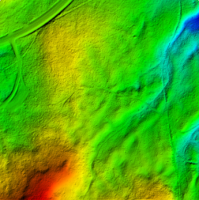
It is relatively straightforward to use SAGA GIS to import the LiDAR LAS file, to extract out a subset containing only the ground points, and then to interpolate the points into a bare earth surface model. I tried out the following steps to create an ESRI ArcGrid ASCII file of the bare earth ground surface.
Import the LiDAR LAS file
- Start up SAGA GIS. Select Modules | File | Shapes | Import | Import LAS Files.
The Import LAS Files dialog box appears. - Select the Input File row. Click the [...] button on the right. In the Open dialog box, browse and select the LAS file, e.g. lub_tile1.las. Click Open.
The selected file name is displayed in the Import LAS Files dialog box. - In the Attributes to import besides x,y,z list, toggle on classification and any other attributes you want.

- Click Okay.
The LAS file is imported into SAGA GIS.
Extract out Ground points
- Select Modules | Shapes | Point Clouds | Tools | Point Cloud Reclassifier / Subset Extractor.
The Point Cloud Reclassifier / Subset Extractor dialog box appears.
- Click the Point Cloud row. Choose the newly imported point cloud in the drop down list, e.g. 01.lub_tile1.
- Click the Point Cloud Attribute row. Choose classification.
- In the Mode of operation row, choose Extract Subset.
- In the Method single old value row, type in 2 for Ground class.
- In the Method single new value row, type in 2 to keep it the same value in the subset.

- Click Okay.
The point cloud subset of only Ground points is created. By default, the new layer will have the string subset_classification appended to the input name.
Interpolating the bare earth ground surface
- Select Modules | Grid | Gridding | Interpolation from Points | Triangulation.
The Triangulation dialog box appears.
Note: Other interpolation algorithm is also fine depending on your requirements. - In the Points row, choose the newly created subset e.g. 02.lub_tile1_subset_classification.
- In the Attribute row, choose Z.

- Click Okay.
The User Defined Grid dialog box appears. - Optional. In the Cellsize row, type in the desired output cell size e.g. 1.

- Click Okay.
The grid layer is created.
Exporting the bare earth surface in ESRI ArcGrid ASCII format
- Select Modules | File | Grid | Export | Export ESRI Arc/Info Grid.
The Export ESRI Arc/Info Grid dialog box appears.
- In the Grid system row, choose the grid system of the bare earth surface grid layer, e.g. 1;684x 685y; 312479.7x 5195216.9y.
- In the Grid row, choose the bare earth grid layer, e.g. 01.lub_tile1_subset_classification(Triangulation).
- In the File row, click the [...] button. Browse and specify the output file name, e.g. C:\Temp\dtm.asc. Click Save.

- Click Okay.
The bare earth ground surface is exported out.

Really nice post, what I was looking for. I heard the great potentialities of SAGA but still I am impressed.
ReplyDeleteI am evaluating the LiDAR Analyst for ArcMap and I would say SAGA is working better so far..
Thanks,
Marco
thanks Marco. SAGA GIS is all right but be watchful of bugs - I found quite a few esp. with void data handling.
ReplyDeleteHi, I have a problem. I have followed your steps and still couldn't export the bare earth surface in ESRI ArcGrid ASCII format. What could be the problem?
ReplyDeleteHi, I have problems with exporting the bare earth surface in ESRI ArcGrid ASCII format.. I have followed your steps.. What yould be the problem?
ReplyDeleteMiss Blossom, maybe you want to give more details? There is also a helpful user community at http://sourceforge.net/projects/saga-gis/forums
ReplyDeleteI found out what the problem was. Bad .las files..Thank you for your qiuck answer!
ReplyDeleteBest regards,
Blossom