
To use the web app to apply coordinate transformations to one or more raster files, just do the following:
- In the sidebar on the right, define the transformation parameters - the x and y translation offsets, the scale factor, the rotation angle (positive clockwise), and the rotation/scaling origin.
- Then either drag and drop the ESRI world files (*.tfw, *.pgw, *.jgw, etc.) onto the dashed box area. Or click the button and select one or more ESRI world files.
The source world files are read and transformed. The resultant matrices are displayed in the browser page.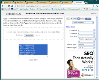
- Copy and paste the resultant matrix into a text editor. Save as a file with the same name as the original world file.

- To see the transformation results, simply display the raster file in a GIS software that recognized world files e.g. Global Mapper.

Before 
After

2 comments:
This is a great tool, but how do I figure out the translation parameters? If I have a a world file in one coordinate system, how do I know how to manipulate it to change it to another?
Hi SciRefDesk, to do transformation from one geo-coordinate reference system to another is not a trivial matrix transformation like what this tool is doing. You have to use a proper geo-transformation tool like Proj4, QGIS, SAGA GIS, etc. (free), or commercial GIS software offerings.
Post a Comment