Showing posts with label Earthquakes. Show all posts

Friday, March 13, 2026

Quakemon - Monitor Earthquakes Android App


Monitor earthquakes, volcano eruptions across countries with Quakemon.


Stay informed with up-to-date incidents and live camera views, all presented through an intuitive map and list interface designed for quick situational awareness.

Key Features:

1. Multi-Countries Earthquakes Monitoring
View earthquake incidents across supported countries using an interactive map or a clear, scrollable list.

2. Detailed Incident Information
Tap any incident in the list or on the map to view detailed information, including location and incident magnitude.

3. Live Volcano Cameras
Tap a camera marker to instantly view a live, zoomable volcano image for real-time conditions.

4. Powerful Filtering
Filter incidents by tags to hide unwanted information and focus only on what matters to you.

5. Camera Favorites
Save frequently used cameras to a favourites list and reorder them for quick and easy access.

Quakemon makes it easy to monitor earthquake events efficiently and stay informed.

Data Sources

Earthquakes and environmental data used in this app may be provided by:

1. Earth Sciences New Zealand (https://earthscience.nz)
2. Geoscience Australia (https://earthquakes.ga.gov.au)
3. GEOFON program of the GFZ Helmholtz Centre for Geosciences Germany(https://geofon.gfz.de)
4. Institute of Geodynamics - National Observatory of Athens (NOA-IG) Greece (https://bbnet.gein.noa.gr)
5. Istituto Nazionale di Geofisica e Vulcanologia Italy (https://terremoti.ingv.it)
6. Kandilli Observatory and Earthquake Research Institute (KOERI) and Regional Earthquake-Tsunami Monitoring Center (RETMC) Turkey (http://www.koeri.boun.edu.tr)
7. BMKG (Badan Meteorologi, Klimatologi, dan Geofisika) Indonesia (https://data.bmkg.go.id)
8. Natural Resources Canada (https://www.earthquakescanada.nrcan.gc.ca)
9. British Geological Survey (UK) (https://earthquakes.bgs.ac.uk)
10. European-Mediterranean Seismological Centre (EMSC) (https://www.emsc-csem.org)
11. USGS (https://www.usgs.gov)

 Download and try out the Quakemon app from the Google Play Store:

Get it on Google Play 

Monday, May 20, 2013

Android App for monitoring natural disasters

You can monitor natural disasters around the world, as published by the Global Disaster Alert and Coordination System - www.gdacs.org with this Android App. The app shows the latest natural disasters like earthquakes, volcano eruptions, tropical cyclones, tsunamis and floods as color coded icons in a list as well as on a Google Maps backdrop; the icon colors indicate the alert level - green, orange, and red. The icon will look more transparent the older the event was published. 

The list view can be used to sort the natural disaster events according to the date time, region, and disaster type. 

Clicking on an item on the list will bring up more details about the disaster event.

To view more information about the event, clicking the Browser button will open up the source GDACS web page with more details, as shown below.

On the other hand, clicking the Map button will bring up a Google Map view of the event, as shown below.


Download the app from the Google Play store. 
Get it on Google Play

Monday, January 7, 2013

Earthquake Monitor Web App

Since Google has announced that it will be closing down the iGoogle site, I decided to migrate some of the Google Gadgets that I had written to Chrome Web Apps for the Chrome Web Store. I consolidated the various earthquake gadgets using the USGS, British Geological Survey, Euro-Mediterranean Seismic Monitoring Center, and the New Zealand GeoNet earthquake feeds into a single Web App.

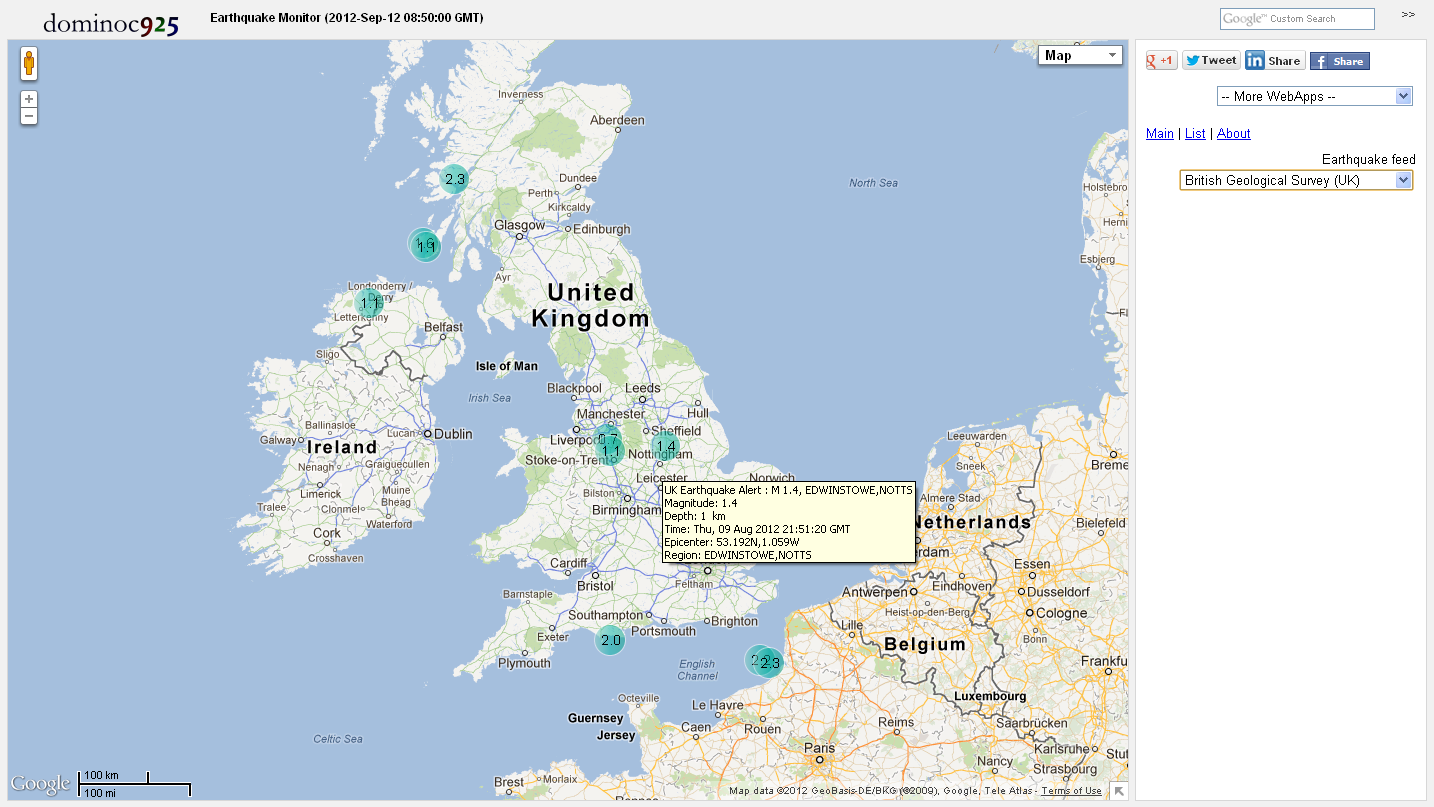
The screenshot below shows the Earthquake Monitor Web App. It can be installed through the Chrome Web Store (search for Earthquake Monitor) or directly from this url address http://dominoc925-pages.appspot.com/webapp/quakemon/default.html.


Simply choose an earthquake source feed in the side bar's Earthquake feed combo box as shown below.

The earthquake epicenters will be displayed as color coded icons by depth and time on Google Maps. Hovering the cursor on the icons will display a tool tip showing summary details about the earthquake event. Clicking on the icon will open up a page showing more detailed information.


Clicking on the List link in the side bar will display a list view of the earthquake events. The list can be sorted according to the time, depth or magnitude of the earthquake event. Clicking on the Map link will center and zoom to the earthquake epicenter in Google Maps.


Monday, July 18, 2011

Google Gadget for monitoring UK earthquakes


This gadget will allow you to subscribe to the British Geological Survey (BGS)'s recent UK earthquake GeoRSS feed. It shows the latest earthquakes as color coded (by depth and age) icons with tool tips on a Google Maps backdrop - the older the earthquake, the more transparent the icon will look.

The gadget has a list tab which displays the earthquake information as a text list with hyperlinks for more details - the list can be sorted by the earthquake magnitude, depth as well as the date-time. Using the list, you can easily find and locate the largest, the latest or the deepest earthquakes.

You can leave this gadget on the screen and it will update itself as it receives the latest feed. Upon receiving the data, it will automatically zoom to the latest earthquake epicenter. Clicking on an earthquake icon will bring up more information about the earthquake from the BGS site.

Monday, November 22, 2010

Monitor New Zealand Earthquakes with this Google Gadget


This gadget will allow you to subscribe to the New Zealand GeoNet real-time earthquake rss feed. It shows the latest earthquakes as color coded (by depth and age) icons with tool tips on a Google Maps backdrop - the older the earthquake, the more transparent the icon will look.

The gadget has a list tab which displays the earthquake information as a text list with hyperlinks for more details - the list can be sorted by the earthquake magnitude, depth as well as the date-time. Using the list, you can easily find and locate the largest, the latest or the deepest earthquakes.

You can leave this gadget on the screen and it will update itself as it receives the latest feed. Upon receiving the data, it will automatically zoom to the latest earthquake epicenter. Clicking on an earthquake icon will bring up more information about the earthquake from the GeoNet site.

Monday, October 25, 2010

Google Gadget for monitoring earthquakes (EMSC source)

This gadget will allow you to subscribe to the European-Mediterranean Seismological Center (EMSC) real-time, worldwide earthquake rss feed. It shows the latest 50 earthquakes as color coded (by depth and age) icons with tool tips on a Google Maps backdrop - the older the earthquake, the more transparent the icon will look. 

The gadget has a list tab which displays the earthquake information as a text list with hyperlinks for more details - the list can be sorted by the earthquake magnitude, depth as well as the date-time. Using the list, you can easily find and locate the largest, the latest or the deepest earthquakes for the past day. 

You can leave this gadget on the screen and it will update itself as it receives the latest feed. Upon receiving the data, it will automatically zoom to the latest earthquake epicenter. Clicking on an earthquake icon will bring up more information about the earthquake from the EMSC site.

Monday, September 27, 2010

Google Gadget for monitoring earthquakes (USGS source)

This gadget will allow you to subscribe to the US Geological Survey (USGS) real-time, worldwide earthquake list. It shows the latest magnitude 1 and above earthquakes for the past day as color coded (by depth and age) icons with tool tips on a Google Maps backdrop - the older the earthquake, the more translucent the icon will look. 

The gadget has a list tab which displays the earthquake information as a text list with hyperlinks for more details - the list can be sorted by the earthquake magnitude, depth as well as the date-time. Using the list, you can easily find and locate the largest, the latest or the deepest earthquakes for the past day. 

You can leave this gadget on the screen and it will update itself as it receives the latest feed. Upon receiving the data, it will automatically zoom to the latest earthquake epicenter. Clicking on an earthquake icon will bring up more information about the earthquake from the USGS site.