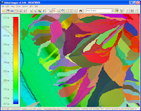
Here are the steps I took to generate the watershed data.
- Start up Global Mapper 12 and load in a digital elevation model as shown below.

- Select File | Generate Watershed.
The Watershed Generation Options dialog box appears.
- Change the X axis and Y axis Resolution if necessary.
- In the Depression Fill Depth field, type in a maximum depth value e.g. 1.

Note: to turn off depression filling, enter 0. - Click OK.
Processing messages appear.

- If you want to generate the watershed basin polygons, then toggle on Create Watershed Areas Showing Drainage to Streams in the Watershed Generation Options dialog box.


1 comment:
Hi to all dominoc925 Readers
- A complete and official Help ref. to Watershed genarating with GlobalMapper 12.01 - one can find here:
http://www.globalmapper.com.pl/watershed_-_help.html
Post a Comment