Once a while I get an unusual request like burning contour vector lines onto
GeoTiff images. It's a good thing the open source software
GDAL has a
gdal_rasterize utility to do the job. Here is an illustrated example of burning vector lines onto a raster image.
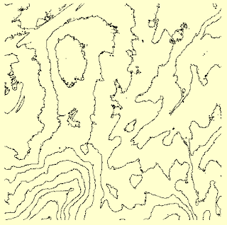 |
| Input vector contour lines |
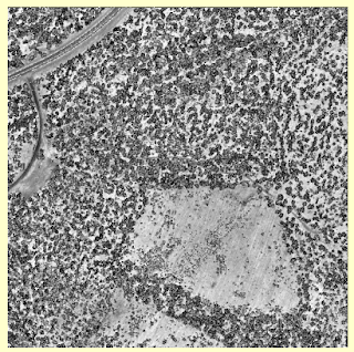 |
| Input raster GeoTiff file |
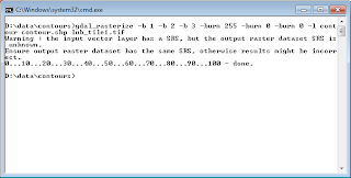
- Open up a Windows Command Prompt.
- Type in the following command, (assuming the GDAL installation bin folder is in the system path).
C:\> gdal_rasterize -b 1 -b 2 -b 3 -burn 255 -burn 0 -burn 0 -l contour contour.shp lub_tile1.tif
Note 1: -burn 255 -burn 0 -burn 0 means burn the RGB color values (255, 0, 0).
Note 2: -b 1 -b 2 -b 3 means to use the three bands of R, G, and B.
Note 3: this utility will overwrite the input raster file, so make sure there is a backup copy of the file.
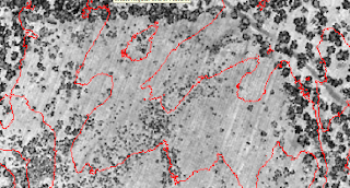
The contour.shp vector lines are burned onto the GeoTiff file lub_tile1.tif.


4 comments:
Thanks for the post. I had to expand the layers of my tiff to hold the three color band layers like below:
[root@mysrv01 /]# gdal_translate -ot Byte -expand rgb /root/wfs2tiff/wmstiff.tif /root/wfs2tiff/wmsnew.tif
Then it worked perfectly for me. Maybe this will help someone else.
To get this working, I had to expand the color layers from 1 layer to 3 layers like so:
[root@mysrv01 /]# gdal_translate -ot Byte -expand rgb /somewhere/wmstiff.tif /somewhere/wmsnew.tif
Then it worked perfectly. Maybe this will help someone else.
Thanks for the post. I had to expand the layers of my tiff to hold the three color band layers like below:
[root@mysrv01 /]# gdal_translate -ot Byte -expand rgb /root/wfs2tiff/wmstiff.tif /root/wfs2tiff/wmsnew.tif
Then it worked perfectly for me. Maybe this will help someone else.
Can you control the output contour line widths in any way?
Thank you for posting this. I was able to overlay lines from a shapefile on top of a geotiff image, but the lines are very thin. Is there another option I could specify to increase the line width output?
Post a Comment