Showing posts with label Google Gadget. Show all posts

Monday, July 8, 2013

Google Gadget for monitoring 911 incident calls in Portland, Oregon

This gadget allows users to monitor the City of Portland, Oregon's Police 911 Dispatch Incidents on a Google Maps backdrop by subscribing to the geoRSS feed of the 100 most recent, closed, non-confidential calls for service received by the City of Portland's 911 system. 

The incidents are shown as clickable and color coded icons with tool tips. Incidents that happened an hour or less ago will be fully opaque; at more than an hour but less than three hours, the icons will be displayed at 50% opacity; at greater than three hours, the icons will be shown at 25% opacity. 

Leave the gadget on the screen and it will update itself every few minutes with the latest information. Clicking on the icon will bring up more details about the incident. Together with Google Street View, users can truly immerse themselves into the incident environment

Monday, January 7, 2013

Earthquake Monitor Web App

Since Google has announced that it will be closing down the iGoogle site, I decided to migrate some of the Google Gadgets that I had written to Chrome Web Apps for the Chrome Web Store. I consolidated the various earthquake gadgets using the USGS, British Geological Survey, Euro-Mediterranean Seismic Monitoring Center, and the New Zealand GeoNet earthquake feeds into a single Web App.

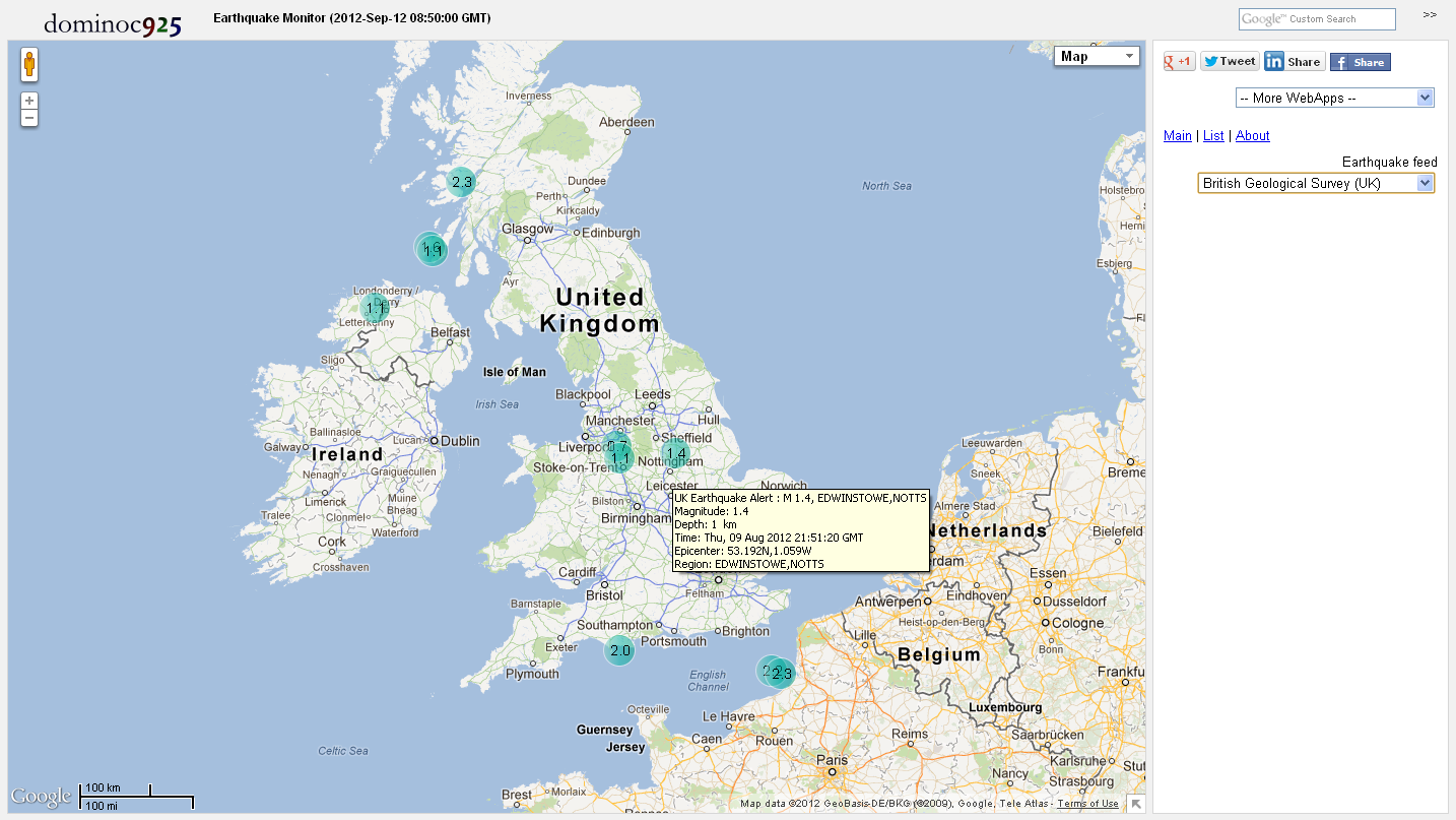
The screenshot below shows the Earthquake Monitor Web App. It can be installed through the Chrome Web Store (search for Earthquake Monitor) or directly from this url address http://dominoc925-pages.appspot.com/webapp/quakemon/default.html.


Simply choose an earthquake source feed in the side bar's Earthquake feed combo box as shown below.

The earthquake epicenters will be displayed as color coded icons by depth and time on Google Maps. Hovering the cursor on the icons will display a tool tip showing summary details about the earthquake event. Clicking on the icon will open up a page showing more detailed information.


Clicking on the List link in the side bar will display a list view of the earthquake events. The list can be sorted according to the time, depth or magnitude of the earthquake event. Clicking on the Map link will center and zoom to the earthquake epicenter in Google Maps.


Monday, May 28, 2012

Google Mapplet for showing local coordinates

This Google Mapplet was written to show the local projected coordinates for any clicked point on Google Maps. Run it from this website http://dominoc925-pages.appspot.com/mapplets/cs_readout.html.


The mapplet currently supports only the following projection types: Cassini-Soldner, Mercator, Oblique Mercator and Transverse Mercator. The datum transformation between the WGS84 datum used by Google Maps and the local projection datum is done using the Standard Molodensky transformation. The transformation parameters of the datums and ellipsoid parameters are taken from this University of Colorado site http://www.colorado.edu/geography/gcraft/notes/datum/edlist.html.

Define and save projection parameters
There are probably hundreds of projection parameter sets in use in the world - too many to keep track. A facility has been built in using some HTML5 features to allow projection parameters to be changed, saved and named, and reuse in the current browser.


  1. In the Side bar on the right, click the Projection link.
  2. In the Projection combo box, select any default projection parameter set e.g. British National Grid.
  3. Change any parameters e.g. Longitude of origin.
  4. Click Save projection as.

    A text entry field appears.
  5. Type in a meaningful name e.g. MyProjection. Click Ok.

    The projection parameters are saved and named as MyProjection.

    Simply select the saved projection to use it for the coordinate readout

Monday, January 2, 2012

Google Gadget for creating ESRI World Files


Note: A WebApp version of this Google Gadget will be up in a short while to replace this gadget.

The ESRI World file is a text file used to georeference a corresponding image file. A detailed description of the format can be found in this Wikipedia page http://en.wikipedia.org/wiki/World_file.

Recently I had to create ESRI World files for hundreds of aerial photographs, each having different origin, resolution and orientation. As a result of that exercise, I learnt enough about the World File format to create this Google Gadget.

This gadget can help to create the world files given the following input parameters:
  1. X coordinate of the upper left pixel in ground units,
  2. Y coordinate of the upper left pixel in ground units,
  3. Size of the pixel in the X-axis direction in ground units,
  4. Size of the pixel in the Y-axis direction in ground units,
  5. Rotation angle in degrees of the image from North (clockwise is positive) 
Just fill in the required input, click the button and copy and paste the results into a world file, which must be named according to the type of image file. For example, the World file should have the file extension of .tfw for associating with TIFF images.


Monday, December 26, 2011

Google Gadget for monitoring crime incidents in Malaysia


This is a Google Gadget for monitoring crime incidents in Malaysia; the incidents are posted by users of www.malaysiacrime.com. The gadget works by subscribing to the georss feed of www.malaysiacrime.com site and displaying the incidents over a Google Maps backdrop. The crime incidents are icons color coded according to the categories - general, rempit, gun, parang, rape, and murder. There is also a list view which can be used to sort the crime incidents according to the date and time. Clicking on the icon will bring up more details about the crime incident.

Monday, September 19, 2011

Convert local date time to GPS week, seconds of week Google Gadget


Note: A WebApp version of this Google Gadget is available at https://dominoc925-pages.appspot.com/webapp/calc_timegps/

This Google Gadget calculator can convert the local date time values into the equivalent GPS week and seconds of week format. The GPS leap seconds from 1980 till 2012 are taken into account in the conversion now.  This came about since I found that in some situations, I need to find out the equivalent GPS week and seconds of week for a given local date time. So I wrote this gadget to do the job. 

To use this calculator, 
  1. Simply select your time zone.
  2. Then type in the local date time.

    Note: The time should be entered in 24HR form. It is not necessary to fill in all local date time fields - the calculator will use zero values in place of blank fields.
  3. Then click the Convert to GPS time button.

    If the keyed in local date time values do not represent a valid date time string, then the calculator will simply display an error 'Invalid date time' message. Otherwise, the GPS week and seconds of week values will be shown in the GPS Time field.

Monday, July 18, 2011

Google Gadget for monitoring UK earthquakes


This gadget will allow you to subscribe to the British Geological Survey (BGS)'s recent UK earthquake GeoRSS feed. It shows the latest earthquakes as color coded (by depth and age) icons with tool tips on a Google Maps backdrop - the older the earthquake, the more transparent the icon will look.

The gadget has a list tab which displays the earthquake information as a text list with hyperlinks for more details - the list can be sorted by the earthquake magnitude, depth as well as the date-time. Using the list, you can easily find and locate the largest, the latest or the deepest earthquakes.

You can leave this gadget on the screen and it will update itself as it receives the latest feed. Upon receiving the data, it will automatically zoom to the latest earthquake epicenter. Clicking on an earthquake icon will bring up more information about the earthquake from the BGS site.

Monday, May 30, 2011

Convert between GDM2000 and Peninsular Malaysian States Cassini coordinates using this Google gadget

Note: This Google Gadget no longer works as Google no longer supports Gadgets on web sites. A WebApp version is available on this site http://dominoc925-pages.appspot.com/webapp/gdm2000cassini/default.html.

GDM2000 or Geodetic Datum of Malaysia 2000 and Cassini-Soldner are coordinate systems commonly used in the Peninsular Malaysia States of Johor, Negri Sembilan, Melaka, Pahang, Selangor, Terengganu, Penang/Seberang Perai, Kedah, Perlis, Perak and Kelantam. This Google Gadget will allow you to convert between one or more pairs of State Cassini easting, northing coordinates and geographical GDM2000 latitude, longitude (GRS80) coordinates, all on GRS80 ellipsoid. It is possible to enter your own Cassini-Soldner projection parameters.

To convert easting,northing to latitude,longitude
  1. Select the Main tab (if it is not active)
  2. Type in one or more easting and northing coordinates in the Easting, northing text box, e.g. 8813.252,-23740.096.
  3. Click the Convert to Latitude,Longitude button (black pointing downward triangle).
To convert latitude,longitude to easting,northing
  1. Select the Main tab (if it is not active)
  2. Type in one or more latitude and longitude coordinates in the Latitude,northing text box e.g. 1:49:39.95355,103:38:24.93554.
  3. Click the Convert to Easting,Northing button (black pointing upward triangle)

To change the State Parameters
  1. Select the Prefs tab.
  2. Select the Use Cassini Parameters drop down list and choose a Peninsular Malaysian state e.g. Johor.

    The selected State's Cassini-Soldner parameters will be used for the conversion .

    Note: if you want to enter your own parameters, choose User-defined and type in the origin parameters

To change the coordinates delimiter character
  1. Select the Prefs tab.
  2. Select the Delimiter character drop down list and choose a character e.g. comma.

    The selected character will be the delimiter for your new key in coordinates and destination coordinates .
To change the latitude,longitude coordinate format
  1. Select the Prefs tab.
  2. Select the Latitude, longitude format drop down list and choose a format e.g. D:M:S.

    The selected format will be the format for your new key in latitude,longitude coordinates or the destination latitude,longitude coordinates.

Monday, May 16, 2011

Convert GPS week/seconds to local date time Google Gadget

Note: A WebApp version of this Google Gadget is available here http://dominoc925-pages.appspot.com/webapp/calc_gpstime/default.html.

The GPS date is normally expressed as a week number and a seconds-into-week number. This format is not quite as easy to work with as normal date time. For that reason, this calculator was written to help convert the GPS week-seconds format into a local date time form that can be easier to read. The gadget will incorporate the GPS leap seconds from 1980 to 2012 into the conversion.

For more information about GPS Time, go to http://www.oc.nps.edu/oc2902w/gps/timsys.html.

To use the calculator, simply do the following:
  1. Enter the GPS Week and GPS Seconds with a comma as the delimiter, 
  2. Select the desired local time zone, and 
  3. If necessary, select the desired local date time format in the Pref tab. 
  4. Click the Convert to local time button


Monday, November 22, 2010

Monitor New Zealand Earthquakes with this Google Gadget


This gadget will allow you to subscribe to the New Zealand GeoNet real-time earthquake rss feed. It shows the latest earthquakes as color coded (by depth and age) icons with tool tips on a Google Maps backdrop - the older the earthquake, the more transparent the icon will look.

The gadget has a list tab which displays the earthquake information as a text list with hyperlinks for more details - the list can be sorted by the earthquake magnitude, depth as well as the date-time. Using the list, you can easily find and locate the largest, the latest or the deepest earthquakes.

You can leave this gadget on the screen and it will update itself as it receives the latest feed. Upon receiving the data, it will automatically zoom to the latest earthquake epicenter. Clicking on an earthquake icon will bring up more information about the earthquake from the GeoNet site.

Monday, November 15, 2010

A Google Gadget for monitoring natural disasters

You can use this gadget to monitor natural disasters around the world as published by the Global Disaster Alert and Coordination System (http://www.gdacs.org).

It shows the latest natural disasters like earthquakes, volcano eruptions, tropical cyclones, and floods as color coded icons with tool tips on a Google Maps backdrop; the icon colors indicate the alert level - green, orange, and red. The icon will look more transparent the older the event was published.

There is also a list view which can be used to sort the natural disaster events according to the date/time, region, and disaster type. Clicking on the icon will bring up more details about the disaster event.

Monday, October 25, 2010

Google Gadget for monitoring earthquakes (EMSC source)

This gadget will allow you to subscribe to the European-Mediterranean Seismological Center (EMSC) real-time, worldwide earthquake rss feed. It shows the latest 50 earthquakes as color coded (by depth and age) icons with tool tips on a Google Maps backdrop - the older the earthquake, the more transparent the icon will look. 

The gadget has a list tab which displays the earthquake information as a text list with hyperlinks for more details - the list can be sorted by the earthquake magnitude, depth as well as the date-time. Using the list, you can easily find and locate the largest, the latest or the deepest earthquakes for the past day. 

You can leave this gadget on the screen and it will update itself as it receives the latest feed. Upon receiving the data, it will automatically zoom to the latest earthquake epicenter. Clicking on an earthquake icon will bring up more information about the earthquake from the EMSC site.

Monday, September 27, 2010

Google Gadget for monitoring earthquakes (USGS source)

This gadget will allow you to subscribe to the US Geological Survey (USGS) real-time, worldwide earthquake list. It shows the latest magnitude 1 and above earthquakes for the past day as color coded (by depth and age) icons with tool tips on a Google Maps backdrop - the older the earthquake, the more translucent the icon will look. 

The gadget has a list tab which displays the earthquake information as a text list with hyperlinks for more details - the list can be sorted by the earthquake magnitude, depth as well as the date-time. Using the list, you can easily find and locate the largest, the latest or the deepest earthquakes for the past day. 

You can leave this gadget on the screen and it will update itself as it receives the latest feed. Upon receiving the data, it will automatically zoom to the latest earthquake epicenter. Clicking on an earthquake icon will bring up more information about the earthquake from the USGS site.

Monday, June 14, 2010

Google Gadget for showing UTM Grid Zones of the world

The Universal Transverse Mercator (UTM) coordinate system is a grid-based system for specifying locations on the earth's surface. UTM consists of 60 zones, each with its own local Transverse Mercator projection. This gadget will allow you to display UTM grid zones of the world with labels on Google Maps.

Monday, May 24, 2010

GDM2000 - BRSO (GRS80) Coordinates Conversion Calculator

Note: A WebApp version of this Google Gadget is available here http://dominoc925-pages.appspot.com/webapp/gdm2000brso/default.html.

GDM2000 or Geodetic Datum of Malaysia 2000 and BRSO or Borneo Rectified Skew Orthomorphic are coordinate systems commonly used in East Malaysia. This Google Gadget will allow you to convert between one or more pairs of BRSO easting, northing coordinates and geographical GDM2000 latitude, longitude (GRS80) coordinates, all on GRS80 ellipsoid.

Monday, May 10, 2010

GDM2000 - MRSO(Peninsular) on GRS80 Ellipsoid Coordinates Converter

Note: A WebApp version of this Google Gadget is available here http://dominoc925-pages.appspot.com/webapp/gdm2000mrso/default.html.

GDM2000 or Geodetic Datum of Malaysia 2000 and MRSO(Peninsular) or Malayan Rectified Skew Orthomorphic are coordinate systems commonly used in Peninsular or West Malaysia. Thie Google Gadget will allow you to convert between one or more pairs of MRSO(Peninsular) easting, northing coordinates and geographical GDM2000 latitude, longitude (GRS80) coordinates, all on GRS80 ellipsoid.

Friday, April 30, 2010

Google Gadget for creating charts on Singapore's OneMap

The Singapore Land Authority (SLA) launched an alternative to Google Maps recently - called OneMap. It's built on ESRI's ArcGIS server and it comes with its OneMap Javascript API, which is essentially a wrapper around ESRI's API. This gives me a chance to work with ESRI's Javascript API and I decided to port the Charting Google Mapplet I wrote earlier to OneMap. The figure below is a screen shot of the gadget running in iGoogle's expanded Canvas mode.
This gadget will create pie charts on Singapore's OneMap from text files formatted as comma separated values (CSV). The CSV data must have a header row, SVY21 easting and northing columns to point to the locations to place the charts on. The charts created can be clicked on to show the values. 

For IE8 users, please run in IE7 or IE8 compatibility mode as IE8 breaks OneMap.The figure below shows the problem of OneMap with Internet Explorer 8 on iGoogle. I am not able to determine the source of the problem but you can click IE's Page button and choose Compatibility View Settings to turn add google.com to the Compatibility View websties .


 To run this gadget, click this link http://www.google.com/ig/adde?moduleurl=http://dominoc925-pages.appspot.com/gadgets/chart_onemap_ig.xml&source=imag.


Thursday, April 15, 2010

Google Gadget for SVY21 Coordinates Conversion Calculator

Note: A WebApp version of this Google Gadget is available here http://dominoc925-pages.appspot.com/webapp/calc_svy21/default.html.

SVY21 is a Transverse Mercator projection (with a WGS84 datum) commonly used in Singapore. This Google Gadget will allow you to convert between one or more pairs of SVY21 easting, northing coordinates and geographical latitude, longitude coordinates. The gadget can be embedded to your iGoogle home page or your web page.


Thursday, April 1, 2010

Singapore Weather Google Gadget

This embedded Google Gadget shows the current weather in Singapore on a Google Maps backdrop. You can leave this gadget on the screen and it will update itself with the latest weather information from the National Environment Agency (NEA) rss feed. The weather information is displayed as icons which will display tool tips of the location as you hover over the icons.