
For convenience, the full list of the dataset extracted from the service is shown below:
| Layer | Url |
|---|---|
| Viking Color Mosaic - Global Map | https://api.nasa.gov/mars-wmts/catalog/Mars_Viking_MDIM21_ClrMosaic_global_232m/1.0.0//default/default028mm/{z}/{y}/{x}.jpg |
| CTX Mosaic - Curiosity Landing Site | https://api.nasa.gov/mars-wmts/catalog/curiosity_ctx_mosaic/1.0.0//default/default028mm/{z}/{y}/{x}.png |
| HiRISE Mosaic - Curiosity Landing Site | https://api.nasa.gov/mars-wmts/catalog/curiosity_hirise_mosaic/1.0.0//default/default028mm/{z}/{y}/{x}.png |
| HiRISE Mosaic - ESP_040776_2115 | https://api.nasa.gov/mars-wmts/catalog/ESP_040776_2115_RED_A_01_ORTHO/1.0.0//default/default028mm/{z}/{y}/{x}.png |
| HiRISE Mosaic - ESP_042252_1930_RED_B_01_ORTHO | https://api.nasa.gov/mars-wmts/catalog/ESP_042252_1930_RED_B_01_ORTHO/1.0.0//default/default028mm/{z}/{y}/{x}.png |
| HiRISE Mosaic - ESP_042647_1760_RED_B_01_ORTHO | https://api.nasa.gov/mars-wmts/catalog/ESP_042647_1760_RED_B_01_ORTHO/1.0.0//default/default028mm/{z}/{y}/{x}.png |
| HRSC Mosaic - Martian East | https://api.nasa.gov/mars-wmts/catalog/HRSC_Martian_east/1.0.0//default/default028mm/{z}/{y}/{x}.png |
| HRSC Color Mosaic - MC11 | https://api.nasa.gov/mars-wmts/catalog/MC11E_HRMOSCO_COL/1.0.0//default/default028mm/{z}/{y}/{x}.png |
| HRSC Mosaic - MC11 | https://api.nasa.gov/mars-wmts/catalog/MC11E_HRMOSND_ND5/1.0.0//default/default028mm/{z}/{y}/{x}.png |
| HiRISE Mosaic - Spirit Landing Site | https://api.nasa.gov/mars-wmts/catalog/spirit_hirise_mosaic/1.0.0//default/default028mm/{z}/{y}/{x}.png |
| HiRISE Mosaic - Opportunity Landing Site | https://api.nasa.gov/mars-wmts/catalog/opportunity_hirise_mosaic/1.0.0//default/default028mm/{z}/{y}/{x}.png |
| HiRISE Mosaic - Phoenix Landing Site | https://api.nasa.gov/mars-wmts/catalog/phoenix_hirise_mosaic/1.0.0//default/default028mm/{z}/{y}/{x}.png |
| HiRISE Mosaic - Sojourner Landing Site | https://api.nasa.gov/mars-wmts/catalog/sojourner_hirise_mosaic/1.0.0//default/default028mm/{z}/{y}/{x}.png |
| Albedo Mosaic - Thermal Emission Spectrometer | https://api.nasa.gov/mars-wmts/catalog/Mars_MGS_TES_Albedo_mosaic_global_7410m/1.0.0//default/default028mm/{z}/{y}/{x}.png |
| DEM Grayscale - Mars Orbiter Laser Altimeter | https://api.nasa.gov/mars-wmts/catalog/Mars_MGS_MOLA_DEM_mosaic_global_463m_8/1.0.0//default/default028mm/{z}/{y}/{x}.png |
| Color Hillshade - Mars Orbiter Laser Altimeter | https://api.nasa.gov/mars-wmts/catalog/Mars_MGS_MOLA_ClrShade_merge_global_463m/1.0.0//default/default028mm/{z}/{y}/{x}.jpg |
| Experience Curiosity - Curiosity Landing Site | https://api.nasa.gov/mars-wmts/catalog/mars_pahrump_patch_8k_256m/1.0.0//default/default028mm/{z}/{y}/{x}.png |
| Atlas Mosaic - Mars Orbiter Camera | https://api.nasa.gov/mars-wmts/catalog/msss_atlas_simp_clon/1.0.0//default/default028mm/{z}/{y}/{x}.png |
| Infrared Night - Thermal Emission Imaging System | https://api.nasa.gov/mars-wmts/catalog/Mars_MO_THEMIS-IR-Night_mosaic_60N60S_100m_v14_clon0_ly/1.0.0//default/default028mm/{z}/{y}/{x}.jpg |
| Infrared Day - Thermal Emission Imaging System | https://api.nasa.gov/mars-wmts/catalog/Mars_MO_THEMIS-IR-Day_mosaic_global_100m_v12_clon0_ly/1.0.0//default/default028mm/{z}/{y}/{x}.jpg |
| HRSC Mosaic - Mawrth Vallis | https://api.nasa.gov/mars-wmts/catalog/hrsc_mawrth_vallis/1.0.0//default/default028mm/{z}/{y}/{x}.png |
| HRSC Color Mosaic - Mawrth Vallis | https://api.nasa.gov/mars-wmts/catalog/hrsc_mawrth_vallis_color/1.0.0//default/default028mm/{z}/{y}/{x}.png |
To add a MARS dataset to QGIS, do the following:
- Start QGIS. In the Browser panel, mouse right click on the Tile Server (XYZ). Select New Connection.

- In the New XYZ tile layer, type in the URL for the chosen dataset, e.g. https://api.nasa.gov/mars-wmts/catalog/Mars_MGS_MOLA_ClrShade_merge_global_463m/1.0.0//default/default028mm/{z}/{y}/{x}.jpg
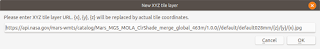
- Click OK.
- Type in the name of the tile layer, e.g. Color Hillshade - Mars Orbiter Laser Altimeter.
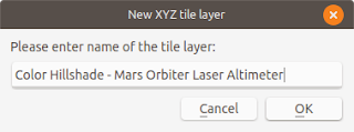
- Click OK.
The tile layer connection is added to the Tile Server (XYZ) node.
- Mouse right click on the newly added tile server node. Choose Add layer.
The selected layer is displayed in QGIS.


